iWater infraMAP GIS Utility Asset Management Software
Overview
About iWater
iWater has been serving utilities across North America since 2000, providing critical water, wastewater, stormwater, gas, and electric infrastructure services. Specializing in real-world GIS data and utility asset management, iWater empowers public works and private utilities to monitor, maintain, and manage infrastructure efficiently. Known for their hands-on industry expertise, iWater supports major clients such as the City of Newport Beach, Golden State Water Company, and Las Vegas Valley Water District.


[Saritasa] offer[s] a broad scope of knowledge and can bring a variety of technologies into a project. They’ve handled some complex app projects with us and were great at blending various components together. We had very good access to people within the organization throughout.
Don RhodesPresident of iWater
Their Challenge
Utility companies depend on accurate, accessible infrastructure data to manage operations, maintenance, and emergency response. A geographic information system (GIS) is a software system used to capture, store, display, and interact with data related to positions on Earth’s surface. The data is attached to a unique location stored in layers, allowing users to understand patterns and relationships between seemingly unrelated data. For example, water-management firms need reliable GIS to map out pipes and determine where work must be done. Yet many GIS systems are cumbersome, outdated, or lack field usability.
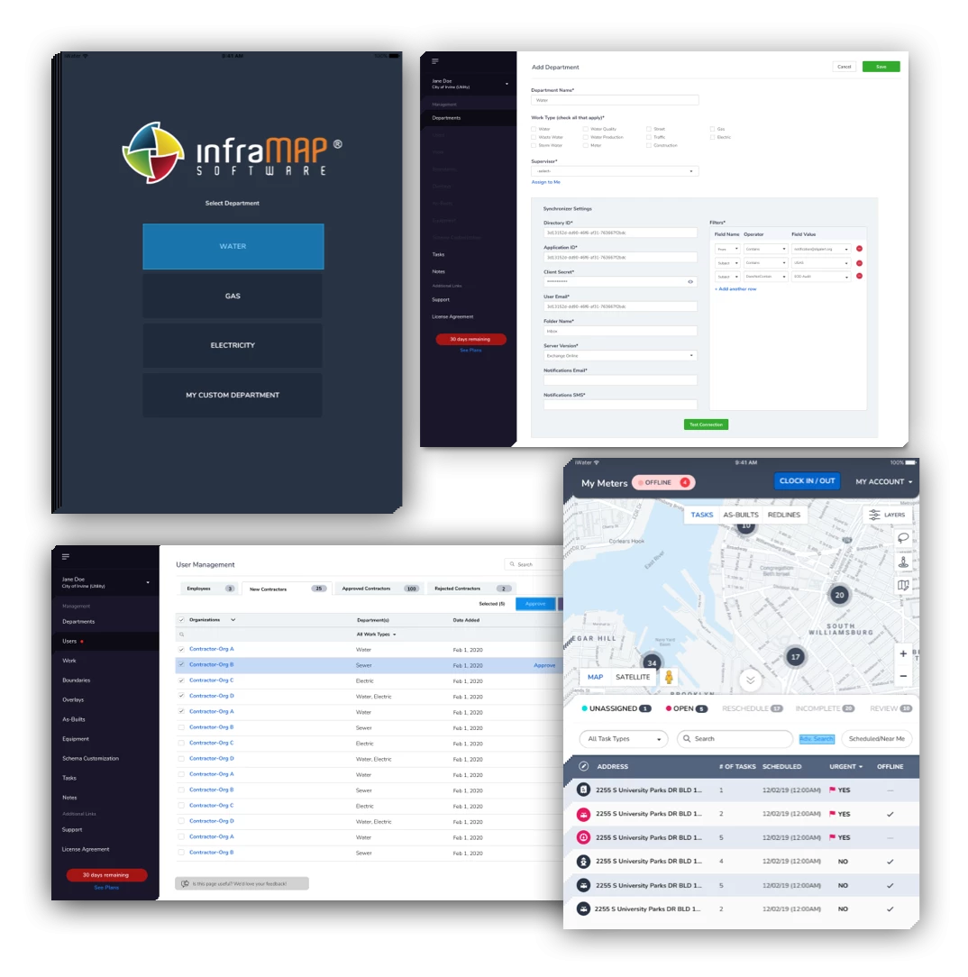
iWater created infraMAP in 2002 as an internal tool to streamline field operations, reduce paperwork, and improve data collection. As infraMAP’s adoption grew beyond iWater’s crews, the company needed a trusted development partner to transform the platform into a scalable, user-friendly utility asset management software that could serve a broad range of industries, from water and gas utilities to public works and private contractors.
Our Solution
Saritasa became iWater’s dedicated technology partner, helping evolve infraMAP into a SaaS-based utility asset management software designed for field crews and administrators alike. We built a robust, GPS-enabled mobile GIS solution that allows teams to collect real-time asset data, update task statuses, and streamline reporting workflows. The solution connects field crews, supervisors, engineers, and management teams within a single unified system tailored for the utility industry’s needs.
Our Approach
What Saritasa Did
Utility Asset Management Software Development
We transformed infraMAP into a flexible SaaS utility asset management software platform, ensuring scalability and ease of use for teams with little or no GIS experience. The application supports drawing on individual map layers, real-time updates, and collaboration between crews in the field and administrators in the office. Its Azure-based infrastructure allows seamless scaling to accommodate growing user bases and diverse industry needs.
Multiple User Types
Utility asset management software must serve a variety of roles and industries. We built in support for multiple user types (administrators, supervisors, field crews, and contractors), each with specific permissions and interfaces. The platform accommodates unique use cases such as pipe and cable maintenance for utilities, emergency response tracking for electrical companies, and specialized inspections like grease trap monitoring for health inspectors.
Customizable Complex Workflows
Field operations often require capturing hundreds of data points. We built a dynamic admin portal where companies can customize fields, task types, icons, and workflows to match their operational needs. The system supports both one-off and recurring tasks like annual maintenance, with built-in reporting tools that give supervisors visibility into task completion and asset management.
Frontend & Backend Development
We developed a responsive front end using Angular.JS for tablet and desktop access, ensuring that complex workflows remained user-friendly in field environments. The backend, built on .NET, supports the robust customization and real-time data handling required by utility asset management software. Our design prioritized intuitive navigation, making complex asset tracking simple and efficient for end users.
High-Precision GPS
Accurate location data is critical in utility asset management software. We integrated high-precision handheld GPS devices, enabling automatic location tracking, live map adjustments, and turn-by-turn navigation. This functionality allows field teams to pinpoint assets, log issues, and complete tasks with maximum efficiency, all while ensuring data accuracy for operations and reporting.